Where to go in South Sardinia is not a simple question. The south of the island covers five distinct macro-areas, each with its own personality: Cagliari and its surroundings, the southeast coast from Villasimius to Costa Rei, the southwest from Chia to Teulada, the Sulcis-Iglesiente with its two inhabited islands, and an inland plateau that few visitors bother to reach.

This guide covers all of them, not as a list of random places, but as a practical map to help you decide where to actually go based on your time, your priorities, and what kind of traveller you are.
One thing first: you need a car. We will come back to this.
South Sardinia at a glance: five areas, one trip
Before diving in, here is an honest overview of the five macro-areas:
| Area | Best for | Drive from Cagliari (CAG) | Best season |
|---|---|---|---|
| Cagliari and surroundings | City, culture, beaches, day trips | 0 km | Year-round |
| Southeast Coast (Villasimius, Costa Rei) | Beaches, diving, marine reserve | 60-75 min | June-September |
| Southwest Coast (Chia, Teulada) | Wild beaches, flamingos, dunes | 45-75 min | May-September |
| Sulcis-Iglesiente (Iglesias, San Pietro, Sant’Antioco) | Islands, mining heritage, wild coasts | 75-120 min | May-October |
| Inland South (Barumini, Giara di Gesturi) | Archaeology, wildlife, landscape | 50-60 min | March-June, September |
This table alone is more useful than most things you will read about South Sardinia. Pick your priorities, check the column, and build your itinerary from there.
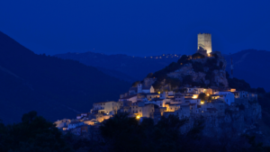
Cagliari and surroundings: the south’s beating heart
No visit to South Sardinia begins without Cagliari. It is the capital of the island, a real Mediterranean city of 150,000 people (about 500.000 for the whole “metropolitan area”), and one of the most underrated destinations in Italy. Tourists often treat it as a transit point on their way to the beach. That is a mistake.
Cagliari

The Castello district sits on a hill above the city: a compact medieval quarter of narrow streets, stone palazzi and bastions with panoramic views over the Gulf. Allow half a day. The nearby Villanova and Stampace neighbourhoods are more working-class and more interesting in many ways: local bakeries, old churches, the kind of bars where the clientele has not changed in thirty years.

San Benedetto Market is one of the largest covered food markets in Italy. Two floors of fresh fish, aged sheep’s cheese, spit-roasted meats and saffron. Go in the morning. Buy something and eat it outside.
Poetto Beach stretches for 8 kilometres east of the city. It is an urban beach, which means it is lined with beach clubs in summer, but the water is genuinely clean and the view of the Sella del Diavolo headland is one of the most dramatic coastal panoramas in the Mediterranean. Cycling along the seafront path at sunset costs nothing and beats most organised tours. For a full guide to what to do: Poetto Beach, Cagliari: guide and best things to do.
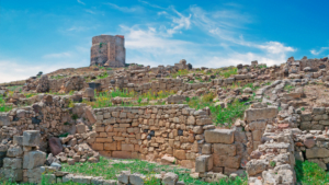
Nora and Pula

40 kilometres south of Cagliari, the ancient city of Nora sits on a peninsula where Phoenicians, then Romans, built what is still the best-preserved archaeological site of its kind in Sardinia. A theatre, mosaic floors, thermal baths, and ruins that extend into the shallow sea.

Snorkelling tours from the small harbour at Nora let you see the submerged sections of the city. The site is 4 kilometres past the town of Pula, which is worth a stop on its own: a Baroque square, good restaurants, and close access to the beaches of Santa Margherita di Pula further south.
Molentargius Natural Park and the flamingos

Ten minutes by car from Cagliari’s seafront, Molentargius is a wetland park that most tourists do not know exists. It is home to one of the largest colonies of greater flamingos in Europe. In spring and early summer, the numbers peak: thousands of birds, accessible from a network of cycle and walking paths. Entry is free. There is very little tourist infrastructure, which is exactly the point.
For anyone based in Cagliari, this is one of the best free half-days available.
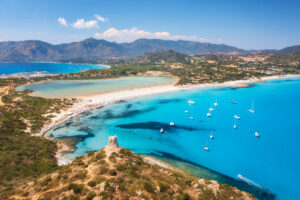
The Southeast Coast: Villasimius and Costa Rei
The southeast is where most visitors picture when they hear “South Sardinia beaches”. They are not wrong. This coastline is genuinely extraordinary, with two distinct destinations that work well together.
Villasimius

Villasimius sits on the southeastern tip of the island, roughly one hour from Cagliari airport. The town itself is low-key: a pedestrian centre with restaurants, gelaterias and a small marina. The beaches are the reason you come.

Porto Giunco is wide, double-curved, and backed by the Stagno di Notteri lagoon, where flamingos nest year-round. The combination of white sand, turquoise water and pink birds in the same frame is hard to overstate. Full Porto Giunco guide and things to do.
Punta Molentis is more intimate, reached by a steep path through scrubland, and protected from most winds. It is smaller and quieter than Porto Giunco, which is part of its appeal. Punta Molentis: guide and things to know.
The entire area falls within the Capo Carbonara Marine Protected Area. Underwater, the biodiversity is significant: Posidonia meadows, grouper, sea turtles and sponge formations. Diving centres in Villasimius are well-organised and have been operating for decades. If underwater exploration interests you: best diving spots and tours in Sardinia.
Costa Rei and the Sarrabus coast
15 kilometres north of Villasimius, Costa Rei is a different kind of place. The main beach runs for 12 kilometres of fine white sand without interruption. The town is small and low-rise, with a population that multiplies in August and drops to almost nothing in October.
Cala Pira, Cala Sinzias and Scoglio di Peppino are the standouts along this stretch. Scoglio di Peppino is a large rock formation in the water, reachable by swimming from the beach, and one of the most photographed spots in all of South Sardinia.
Further north, the Sarrabus area around Muravera is less touristic: river gorges, citrus groves, and small beaches that stay relatively quiet even at peak season. A worthy detour if you have a day to spare and prefer scenery to services.
The Southwest Coast: Chia, Teulada and beyond
The southwest is where South Sardinia gets wilder. The coastline between Pula and Teulada is more rugged, more exposed to wind, and considerably more dramatic in a raw, uncombed sense. It is also the area with the most consistent reputation for world-class beaches.
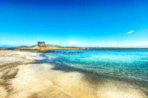
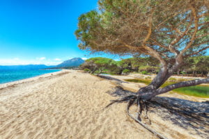
Chia

Chia is 55 minutes south of Cagliari airport. The beaches here, Su Giudeu, Cala Cipolla, and the stretch around Torre di Chia (a 17th-century Spanish watchtower), are consistently ranked among the most beautiful in Italy. The dunes behind Su Giudeu are covered in juniper trees that form a dense, aromatic scrubland. Behind the beach, a lagoon hosts flamingos year-round.

Worth knowing: Chia is exposed to the Maestrale, Sardinia’s prevailing northwest wind. On a windy day in July, the sea at Chia can be choppy while the southeast coast stays calm. Check a local weather app (il.meteo.it or meteomar.it) before making the drive.
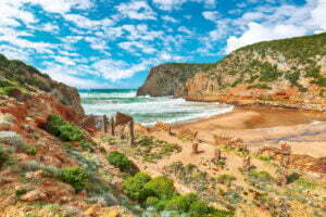
Teulada and Tuerredda

Tuerredda is the beach most associated with the Chia area, though it falls within the municipality of Teulada. The bay is small, almost circular, with a turquoise colour that seems implausible in the Mediterranean, and a tiny island just offshore you can swim to in a few minutes.
It has been voted the most beautiful beach in Italy multiple times, and for once that kind of ranking is not exaggerated.
Practical note: a steep unpaved road leads to the beach. Arrive before 9am in August or expect a full car park and a queue back to the main road. Also note that parts of the Teulada municipality are a military zone, which limits access to certain coastal stretches. Tuerredda itself is fully accessible.
Porto Pino and Sant’Anna Arresi
Further west, Porto Pino is a genuinely undervisited spot. A lagoon, white sand dunes, a pine forest, and a sea that rivals Tuerredda in colour. The area around Sant’Anna Arresi is quiet even in mid-August: no large hotels, local fishing activity still visible, and beaches that reward the slightly longer drive. This is the part of South Sardinia where going slightly off-route pays off.
Sulcis-Iglesiente: islands, mines and wild coasts

Few areas of Sardinia have as much compressed variety as Sulcis-Iglesiente. An hour west of Cagliari, you enter a region shaped by two forces: the sea and centuries of industrial mining. The landscape is dramatic, the coastline is largely intact, and two inhabited islands make the area unlike anything else in the south.
Iglesias and Porto Flavia

Iglesias is a former mining town with a well-preserved medieval centre. The Gothic cathedral, the Spanish-era city walls, and the elegant Piazza Municipio put it in a different category from the average Sardinian inland town. But the real draw is Porto Flavia, 30 minutes west on the coast.
Porto Flavia is a mining port carved directly into a coastal cliff, with loading tunnels opening onto the sea at a vertical height of roughly 100 metres. It operated from the 1920s until mid-century, loading minerals directly onto ships moored below. Today, guided tours take you through the tunnels to the cliff-edge openings. It is one of the most unusual pieces of industrial heritage in the Mediterranean, and barely anyone outside Sardinia knows it exists.
The surrounding Parco Geominerario Storico Ambientale della Sardegna was recognised as one of the first UNESCO Global Geoparks in Europe in the year 2000. The landscape of abandoned mine shafts, early 20th-century engineering offices and wild coastline is unlike anything else on the island.
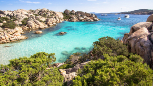
Isola di San Pietro and Carloforte

Isola di San Pietro is reached by a 30-minute ferry from Portovesme (about 90 minutes by car from Cagliari). The only town is Carloforte, and it is one of the most peculiar places in Sardinia: founded in the 18th century by a Ligurian community originally from the island of Tabarca in Tunisia, it still speaks a dialect of Genoese.
The architecture is not what you expect. The food is Ligurian-Sardinian, built around tuna (tonno di corsa), couscous and cassola, a local fish stew. The pace is slow in the best possible way. The island has excellent beaches, good diving, and spectacular basalt cliffs in the south.

Plan a minimum of two nights. One day from Cagliari does not do it justice.
Sant’Antioco

Connected to the mainland by a Roman causeway that is still in use today, Sant’Antioco is the largest island in the Sulcis archipelago and one of the oldest continuously inhabited places in Sardinia. The town sits on top of a Phoenician necropolis. The Tophet, a sacred Phoenician burial precinct, is one of the few sites of this type in the western Mediterranean open to the public. The archaeological museum is small but rigorous and well curated.

The beaches in the south of the island, around Cala Lunga and Cala delle Balene, are wild and uncrowded even in summer. A good base for exploring both Sant’Antioco and San Pietro.
Cala Domestica
On the coast between Buggerru and Masua, Cala Domestica is a narrow inlet protected on three sides by cliffs, formerly used as a shelter by boats serving the nearby mines. The water is extraordinarily clear. Access is via a rough track, and the beach is reached through a short tunnel cut through the rock by miners in the early 1900s. That detail alone makes it worth the drive.
For everything you need to know before you go: Cala Domestica: guide and practical tips.
Inland South Sardinia: nuraghi and wild horses
Most visitors to South Sardinia stay on the coast. Understandable, given the quality of the beaches. But it means missing the two most compelling inland destinations on the island, both reachable from Cagliari in under an hour.
Su Nuraxi di Barumini

Su Nuraxi di Barumini is 55 kilometres north of Cagliari, in the agricultural plain of Marmilla. It is the most important nuragic site in Sardinia and the island’s first UNESCO World Heritage Site, listed in 1997.
The central tower dates to around the 15th century BC. Surrounding it: four subsidiary towers, a curtain wall, and the ruins of a Bronze Age village with hundreds of circular stone huts excavated over decades of archaeological work. The scale is more impressive on the ground than in any photograph.
A guided tour is mandatory on site, and genuinely worth it. The structure is complex and the historical context requires explanation. Guided tours depart regularly throughout the day; book in advance in July and August.
Sardinia has around 7,000 nuraghi scattered across the island, but Su Nuraxi is the one that explains what they are and why they matter. For a broader look at the island’s prehistoric architecture: nuraghe in Sardinia: a complete guide.
Giara di Gesturi

Giara di Gesturi is a basalt plateau sitting at roughly 600 metres above sea level, about 10 kilometres north of Barumini. What makes it remarkable is not the landscape, though it is beautiful, but the animals.
The Giara plateau is home to the last surviving population of Giara horses, a small wild horse endemic to Sardinia. They have lived on this plateau since at least the Bronze Age. The herd is real, not managed like a zoo, and finding them requires walking the plateau.
The best time to look for them is spring, when the plateau’s seasonal ponds fill with water and the horses gather at the water’s edge in groups. In summer the ponds dry up and the horses retreat into the cork oak forest. A local guide on foot increases your chances significantly.
Combine Barumini and the Giara in a single full-day trip from Cagliari. The drive home is under an hour.
Caves

The caves of southern Sardinia are a hidden treasure, offering a fascinating journey into the heart of the earth. Among the most notable are the Is Zuddas Caves in Santadi, where stalactites and stalagmites create fairy-tale scenarios, and the Su Mannau Cave in Fluminimaggiore, a rare karst complex with its immense halls and underground lakes. These natural wonders provide a unique experience, allowing you to discover the geological marvels that lie beneath the surface of Sardinia.
Things to do in South Sardinia: top experiences

South Sardinia works well independently with a hire car. But a guided experience can open places that are hard to reach alone, or add the kind of depth that transforms a visit into something you actually understand. Here are seven experiences worth booking:
Su Nuraxi di Barumini UNESCO Guided Tour from Cagliari
A half-day tour from Cagliari to Su Nuraxi with a local guide, including transport and entry. The guide explains Bronze Age construction techniques, the social structure of nuragic communities, and the significance of the site within Mediterranean prehistory. Private option available. Rated 4.9 with over 150 reviews.
Book on GetYourGuide
Su Nuraxi + Giara Horses Tour, 4 Hours from Cagliari
Combines the UNESCO site with a visit to the Giara plateau to look for the endemic wild horses. Small group, pickup from Cagliari, 4 hours. The most efficient way to cover both inland highlights in a single day. Rated 4.9.
Book on GetYourGuide
From Cagliari: Nora Ruins and Pula Guided Tour
A 4-hour tour to the Phoenician-Roman ruins of Nora with a local guide and private transfer from Cagliari. Includes a stop in Pula village and views of the Santa Gilla flamingo ponds on the way. Practical option for those without a car.
Book on GetYourGuide
Beach Tour to Chia and Tuerredda from Cagliari
An 8-hour small-group day trip to Tuerredda and Su Giudeu beaches, with local guide and transfer included. English, German and Italian spoken. Limited to 8 participants. Perfect for those based in Cagliari who want a full day on the southwest coast without a hire car. Rated 5 out of 5.
Book on GetYourGuide
Southwest Chia and Teulada Private Boat Tour
An inflatable boat tour along the Chia coastline, stopping at up to six hidden coves including Cala Cipolla, the waters around Capo Spartivento and Cala Zafferano near Teulada. Snorkelling gear included. Private and shared options available. The coves visited are only accessible by sea.
Book on GetYourGuide
Villasimius and Solanas Beaches Day Trip from Cagliari
A van-based day trip from Cagliari along the southeast coast, visiting Villasimius and the beaches around Solanas. The route follows the scenic coastal road past Poetto and the flamingo salt flats. Rated 4.8 with over 90 reviews.
Book on Viator
4×4 Mountains and Beaches of the Chia Area
A jeep tour from Cagliari that combines off-road driving through the mountains inland of Chia with beach time on the southwest coast. Includes a stop at Santa Gilla lagoon to spot flamingos. A high-variety day for those who want landscape and nature rather than beach only.
Book on GetYourGuide
Getting around: car rental in South Sardinia
You need a car. This is not a guidebook cliché. It is the single most important practical decision you will make for a trip to South Sardinia. Bus services connect Cagliari to the main towns, but the beaches, the mining sites, Barumini, Porto Flavia, Cala Domestica, and most of what makes this region exceptional are simply not reachable by public transport at a reasonable pace.
Cagliari Elmas Airport (CAG) is the main entry point for the south. Book early: in July and August, availability drops sharply and prices increase significantly.
- Cagliari Airport: compare prices and book on DiscoverCars
- General Sardinia (other airports or flexible entry): DiscoverCars Sardinia
A compact or mid-size car handles almost all roads in South Sardinia. An SUV or 4×4 is useful only if you plan to access unmaintained tracks to beaches like Tuerredda or Cala Domestica.
Where to sleep in South Sardinia
The main focus of this guide is where to go, not just where to stay. But here is a quick, honest selection of accommodation by area:
Villasimius, Premium
Almar Timi Ama Resort and Spa sits inside the Capo Carbonara Marine Protected Area, 10 minutes by shuttle from Porto Giunco beach. Five-star, private beach, full spa with thalassotherapy, four restaurants. One of the best-positioned resort hotels in South Sardinia.
Book on Booking.com
Santa Margherita di Pula (Chia area), Luxury
Forte Village Resort – Il Borgo is a self-contained luxury complex with a private beach, 21 restaurants, sports facilities including football and tennis academies, and a full children’s entertainment programme. A strong choice for families who want everything in one place.
Book on Booking.com
Santa Margherita di Pula, More affordable within the Forte Village complex
Forte Village – Bouganville is part of the same resort but represents a more accessible price point. Access to shared facilities, private beach and pools included.
Book on Booking.com
Cagliari, City base for the whole south
Cagliari is the most practical strategic base for all of South Sardinia. From here, Villasimius, Chia, Barumini and Nora are all day-trip distance. Options range from budget guesthouses in Villanova to boutique hotels inside Castello.
Browse Cagliari hotels on Booking.com
Interactive Map of South Sardinia
Discover the interactive map of Sardinia (South included):
The local perspective: what Sardinians think
Not all of South Sardinia is equal, and marketing tends to flatten the real differences. Here is what actually matters if you are making decisions.
Wind and sea conditions. The Maestrale (northwest wind) is the dominant summer wind of Sardinia. It hits the southwest coast, particularly Chia and Tuerredda, more directly than the southeast. On a windy day in July, Villasimius and Costa Rei will typically be calmer than Chia. The southeast coast has a more sheltered orientation because of how the island curves. If calm sea conditions matter to you, the southeast is the more consistent choice.
August crowds are real, but not uniform. August in South Sardinia is genuinely busy. That said, the pressure is not the same everywhere. Villasimius and Chia reach capacity earlier in the day. Costa Rei and the Sarrabus coast are slightly less pressured. San Pietro Island and Sant’Antioco are noticeably quieter even in the second week of August. If you want to be in the south in peak month and avoid the density, the Sulcis is your best option.
Distances are real. Cagliari to Villasimius is one hour. Cagliari to Chia is 55 minutes. Cagliari to the San Pietro ferry is 90 minutes by car plus 30 minutes on the boat. Barumini is 55 minutes inland from the city. If you want to see the southeast coast, the southwest coast, the Sulcis islands and the inland sites in one trip, you need a minimum of ten days. A week forces you to choose. Choose consciously.
The mining heritage is not a minor attraction. The Parco Geominerario Storico Ambientale della Sardegna, which covers most of Sulcis-Iglesiente, was recognised as one of the first UNESCO Global Geoparks in Europe in 2000. Porto Flavia and the landscape around Buggerru and Iglesias are not filler between beach days. They are an extraordinary layer of history, industrial archaeology and coastal beauty that most visitors to South Sardinia completely miss.
FAQ about South Sardinia
What is the best area to stay in South Sardinia?
Cagliari is the most practical base if you want flexibility and range. From the capital you can reach every macro-area by car in under 90 minutes. If beach time is your priority, Villasimius or Costa Rei offer consistent conditions and a wide range of accommodation. Chia is the best choice for those who want wild, dramatic scenery and do not mind potential wind.
How many days do you need for South Sardinia?
A week is enough to cover one or two areas properly. Ten days or more let you visit all five macro-areas without feeling rushed. With 4-5 days, base yourself in Cagliari and pick one coastal direction, either southeast or southwest.
Is South Sardinia better than North Sardinia?
Different, not better. The north, particularly around Costa Smeralda, is more glamorous and more expensive. The south has more history, a stronger inland dimension, fewer crowds in most areas outside August, and beaches that match or exceed anything in the north. For a full comparison: where to go in North Sardinia: best places.
When is the best time to visit South Sardinia?
May, June and September are the ideal months: warm enough to swim, less crowded, and the landscape at its most varied. July and August are hot, expensive and busy, but the sea conditions are perfect. Spring is excellent for inland and archaeological sites. Winter is mild in Cagliari but most coastal services close entirely.
Do you need a car in South Sardinia?
Yes. For Cagliari alone you can manage with public transport. For everything else, a hire car is not optional. See the car rental section above.
What is the best beach in South Sardinia?
There is no single answer. Tuerredda (Teulada) and Su Giudeu (Chia) are the most photographed. Porto Giunco and Punta Molentis (Villasimius) offer extraordinary diversity in a small area. Cala Domestica (Sulcis-Iglesiente) is the most dramatically situated. For a complete overview: top beaches in Sardinia by a local.
- What is the most important historical site in the south?
The ancient ruins of Nora are a must-see, featuring Roman mosaics right on the edge of the sea. - Where can I find the most impressive sand dunes?
Head to the West Coast to see the towering dunes of Piscinas, a truly desert-like landscape in the heart of the Mediterranean. - What should I see in the capital city?
Spend a day exploring the best attractions in Cagliari, including the Castello district and the Roman Amphitheater.
Sources
- Regione Autonoma della Sardegna, Sardegna Turismo: sardegnaturismo.it
- UNESCO World Heritage List: Su Nuraxi di Barumini (inscribed 1997). whc.unesco.org
- Parco Geominerario Storico Ambientale della Sardegna: UNESCO Global Geopark, recognised 2000. geoparksardegna.it
- Capo Carbonara Marine Protected Area: amp.capocarbonara.it
- Molentargius-Saline Regional Park: parcomolentargius.it
- ISTAT (Italian National Institute of Statistics): municipality population data, latest census
- GetYourGuide: getyourguide.com (activity data verified)
- Viator: viator.com (activity data verified)
- Booking.com: hotel data and reviews verified
- DiscoverCars: discovercars.com (rental data verified)
![]()